
Gemeinde Gaming topographic map
Interactive map
Click on the map to display elevation.
About this map
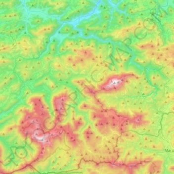
Name: Gemeinde Gaming topographic map, elevation, terrain.
Location: Gemeinde Gaming, Bezirk Scheibbs, Niederösterreich, Österreich (47.74002 15.02821 47.97135 15.26295)
Average elevation: 911 m
Minimum elevation: 354 m
Maximum elevation: 1,882 m
Other topographic maps
Click on a map to view its topography, its elevation and its terrain.
Weitental
Österreich > Niederösterreich > Bezirk Scheibbs > Gemeinde Gaming > Lackenhof
Weitental, Lackenhof, Gemeinde Gaming, Bezirk Scheibbs, Niederösterreich, 3295, Österreich
Average elevation: 1,054 m