
Viterbo topographic map
Interactive map
Click on the map to display elevation.
About this map
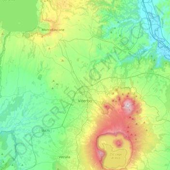
Name: Viterbo topographic map, elevation, terrain.
Location: Viterbo, Latium, Italien (42.29815 11.90455 42.58823 12.22484)
Average elevation: 330 m
Minimum elevation: 54 m
Maximum elevation: 1,065 m
Viterbo liegt 77 km nördlich von Rom und 211 km südöstlich von Florenz. Es befindet sich im Hügelland Tusziens am Fuß der Monti Cimini zwischen dem Bolsenasee und dem Vicosee. Das Gemeindegebiet erstreckt sich über eine Höhe von 86 m s.l.m. bis 896 m s.l.m.
Other topographic maps
Click on a map to view its topography, its elevation and its terrain.