
Make a donation
Cherokee County topographic map
Click on the map to display elevation.
Make a donation
Cherokee County
Cherokee County is the westernmost county in the U.S. state of North Carolina. It borders Tennessee to its west and Georgia to its south. As of the 2010 census, the population was 27,444. The county seat is Murphy, population 1,627 (2010), elevation 1604 ft.
Make a donation
About this map
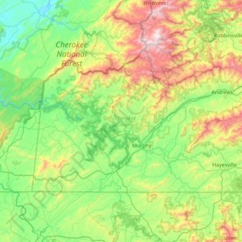
Name: Cherokee County topographic map, elevation, terrain.
Location: Cherokee County, North Carolina, United States (34.98707 -84.32183 35.29225 -83.69010)
Average elevation: 655 m
Minimum elevation: 253 m
Maximum elevation: 1,676 m
Make a donation
Other topographic maps
Click on a map to view its topography, its elevation and its terrain.
Appalachian Mountains
United States > North Carolina > Yancey County
The Appalachian Mountains (French: Appalaches), often called the Appalachians, are a system of mountains in eastern to northeastern North America. The Appalachians first formed roughly 480 million years ago during the Ordovician Period. They once reached elevations similar to those of the Alps and the Rocky…
Average elevation: 1,463 m
Bald Head Island
United States > North Carolina > Brunswick County > Bald Head Island
Average elevation: 3 m
Arden
United States > North Carolina > Buncombe County > Asheville > Royal Pines
Average elevation: 693 m
Make a donation
Bradley Creek Point
United States > North Carolina > New Hanover County > Wilmington
Average elevation: 3 m
Make a donation
Lake Johnson
United States > North Carolina > Wake County > Raleigh > Orchards
Average elevation: 121 m
Make a donation
Make a donation
Little Switzerland
United States > North Carolina > McDowell County
Little Switzerland is an unincorporated community in McDowell and Mitchell counties of North Carolina, United States. It is located along North Carolina Highway 226A (NC 226A) off the Blue Ridge Parkway, directly north of Marion and south of Spruce Pine. The elevation is 3,468 feet (1,057 m) above sea level.
Average elevation: 935 m
Make a donation
Make a donation
Cataloochee Valley Viewpoint
United States > North Carolina > Haywood County > Cataloochee
Average elevation: 1,058 m
Make a donation
Kuwohi
United States > North Carolina > Swain County
At an elevation of 6,643 feet (2,025 m), it is the highest mountain in the Great Smoky Mountains National Park, the highest point in the state of Tennessee, and the highest point along the 2,192-mile (3,528 km) Appalachian Trail. It is also the third highest point in eastern mainland North America, after Mount…
Average elevation: 1,716 m
Make a donation
Lake Raleigh
United States > North Carolina > Wake County > Raleigh > Isle Forest
Average elevation: 104 m
Make a donation
Buckeye Lake
United States > North Carolina > Watauga County > Beech Mountain
Average elevation: 1,160 m
Make a donation
Make a donation
Ravensford
United States > North Carolina > Swain County > Yellowhill Community
Average elevation: 771 m
Elk Knob
United States > North Carolina > Watauga County
Elk Knob is a mountain in the North Carolina High Country, north of the community of Meat Camp. Its elevation reaches 5,538 feet (1,688 m).
Average elevation: 1,362 m
Make a donation
Make a donation
Make a donation
Make a donation
Make a donation
Make a donation
Mount Mitchell
United States > North Carolina > Yancey County
Mount Mitchell, known in Cherokee as Attakulla, is the highest peak of the Appalachian Mountains and the highest peak in mainland eastern North America. It is located near Burnsville in Yancey County, North Carolina; in the Black Mountain subrange of the Appalachians, about 19 miles (31 km) northeast of…
Average elevation: 1,743 m
Make a donation
Make a donation
Valle Crucis
United States > North Carolina > Watauga County
Valle Crucis is located at the banks of Dutch Creek and Watauga River, at an elevation of 2,677 feet (816 m) above sea level. To its north and east is Tester Mountain and to its south and west is Valle Mountain. The community is also within the Pisgah National Forest boundary, which limits some development in…
Average elevation: 904 m
Make a donation
Providence Plantation
United States > North Carolina > Mecklenburg County > Charlotte
Average elevation: 205 m
Make a donation
Reedy Creek Regional Park
United States > North Carolina > Mecklenburg County > Charlotte
Average elevation: 229 m
Make a donation
Make a donation
Cul Res Town Creek Indian Mound
United States > North Carolina > Montgomery County
Average elevation: 71 m
Make a donation
Wilmington Beach
United States > North Carolina > New Hanover County > Carolina Beach
Average elevation: 2 m
Make a donation