
1460 topographic map
Interactive map
Click on the map to display elevation.
About this map
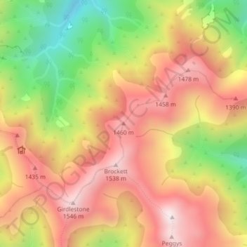
Name: 1460 topographic map, elevation, terrain.
Location: 1460, Carterton District, Wellington, Nouvelle-Zélande (-40.78792 175.45065 -40.78782 175.45075)
Average elevation: 1,211 m
Minimum elevation: 767 m
Maximum elevation: 1,551 m
Other topographic maps
Click on a map to view its topography, its elevation and its terrain.
Arete
Nouvelle-Zélande > Wellington > Carterton District
Arete, Carterton District, Wellington, Nouvelle-Zélande
Average elevation: 1,150 m
1330
1330, Carterton District, Wellington, Nouvelle-Zélande
Average elevation: 1,046 m
Porirua
Nouvelle-Zélande > Wellington > Porirua
Porirua, Porirua City, Wellington, 5022, Nouvelle-Zélande
Average elevation: 115 m
Wellington City
Wellington City, Wellington, Nouvelle-Zélande
Average elevation: 80 m