
Rumoi topographic map
Interactive map
Click on the map to display elevation.
About this map
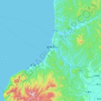
Name: Rumoi topographic map, elevation, terrain.
Location: Rumoi, 留萌振興局, Prefectura de Hokkaidō, 北海道地方, Japón (43.75622 141.25009 44.08873 141.90092)
Average elevation: 155 m
Minimum elevation: -1 m
Maximum elevation: 1,469 m
Other topographic maps
Click on a map to view its topography, its elevation and its terrain.