
Thank you for supporting this site ❤️
Make a donation
Make a donation
Rivage topographic map
Click on the map to display elevation.
Thank you for supporting this site ❤️
Make a donation
Make a donation
About this map
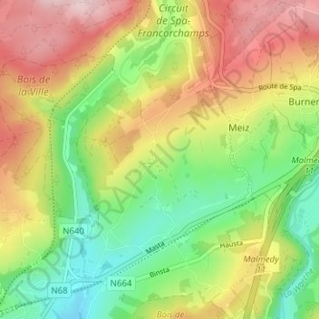
Name: Rivage topographic map, elevation, terrain.
Location: Rivage, Stavelot, Verviers, Liège, Wallonie, 4970, Belgique (50.39917 5.94735 50.43917 5.98735)
Average elevation: 397 m
Minimum elevation: 285 m
Maximum elevation: 531 m
Thank you for supporting this site ❤️
Make a donation
Make a donation
Other topographic maps
Click on a map to view its topography, its elevation and its terrain.