
Thank you for supporting this site ❤️
Make a donation
Make a donation
Rodalben topographic map
Click on the map to display elevation.
Thank you for supporting this site ❤️
Make a donation
Make a donation
Rodalben
Rodalbe liegt in Lothringen, 48 Kilometer südöstlich von Metz, 20 Kilometer nordöstlich von Château-Salins und elf Kilometer westlich von Albestroff (Albesdorf) zwischen Morhange (Mörchingen) und Bénestroff (Bensdorf) auf einer Höhe zwischen 226 und 290 m über dem Meeresspiegel, die mittlere Höhe beträgt 245 m. Das Gemeindegebiet umfasst 10,57 km².
Thank you for supporting this site ❤️
Make a donation
Make a donation
About this map
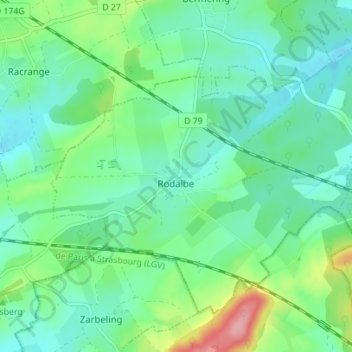
Name: Rodalben topographic map, elevation, terrain.
Average elevation: 258 m
Minimum elevation: 227 m
Maximum elevation: 349 m
Thank you for supporting this site ❤️
Make a donation
Make a donation
Other topographic maps
Click on a map to view its topography, its elevation and its terrain.
Thank you for supporting this site ❤️
Make a donation
Make a donation
Thank you for supporting this site ❤️
Make a donation
Make a donation
Thank you for supporting this site ❤️
Make a donation
Make a donation
Thank you for supporting this site ❤️
Make a donation
Make a donation
Thank you for supporting this site ❤️
Make a donation
Make a donation