
Thank you for supporting this site ❤️
Make a donation
Make a donation
Neduvathoor topographic map
Click on the map to display elevation.
Thank you for supporting this site ❤️
Make a donation
Make a donation
About this map
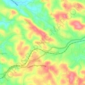
Name: Neduvathoor topographic map, elevation, terrain.
Location: Neduvathoor, Kottarakkara, Kollam, Kerala, 601021, India (8.97544 76.71993 9.01544 76.75993)
Average elevation: 66 m
Minimum elevation: 15 m
Maximum elevation: 112 m
Thank you for supporting this site ❤️
Make a donation
Make a donation
Other topographic maps
Click on a map to view its topography, its elevation and its terrain.