
Thank you for supporting this site ❤️
Make a donation
Make a donation
Edgmont topographic map
Click on the map to display elevation.
Thank you for supporting this site ❤️
Make a donation
Make a donation
About this map
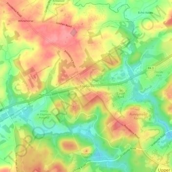
Name: Edgmont topographic map, elevation, terrain.
Average elevation: 102 m
Minimum elevation: 55 m
Maximum elevation: 145 m
Thank you for supporting this site ❤️
Make a donation
Make a donation
Other topographic maps
Click on a map to view its topography, its elevation and its terrain.
Ridley Creek State Park
United States > Pennsylvania > Delaware County > Edgmont Township
Average elevation: 102 m