
Thank you for supporting this site ❤️
Make a donation
Make a donation
Lanjan topographic map
Click on the map to display elevation.
Thank you for supporting this site ❤️
Make a donation
Make a donation
About this map
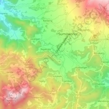
Name: Lanjan topographic map, elevation, terrain.
Average elevation: 978 m
Minimum elevation: 814 m
Maximum elevation: 1,150 m
Thank you for supporting this site ❤️
Make a donation
Make a donation
Other topographic maps
Click on a map to view its topography, its elevation and its terrain.
Alun-Alun Ambarawa
Indonesia > Central Java > Kabupaten Semarang > Tambakboyo > Katang
Average elevation: 499 m