
Thank you for supporting this site ❤️
Make a donation
Make a donation
Mandli Khurd topographic map
Click on the map to display elevation.
Thank you for supporting this site ❤️
Make a donation
Make a donation
About this map
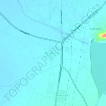
Name: Mandli Khurd topographic map, elevation, terrain.
Location: Mandli Khurd, Pali Tehsil, Pali, Rajasthan, 306400, India (25.71069 73.30055 25.75069 73.34055)
Average elevation: 220 m
Minimum elevation: 213 m
Maximum elevation: 301 m
Thank you for supporting this site ❤️
Make a donation
Make a donation
Other topographic maps
Click on a map to view its topography, its elevation and its terrain.