
Thank you for supporting this site ❤️
Make a donation
Make a donation
Xylokastro topographic map
Click on the map to display elevation.
Thank you for supporting this site ❤️
Make a donation
Make a donation
About this map
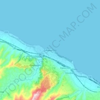
Name: Xylokastro topographic map, elevation, terrain.
Average elevation: 52 m
Minimum elevation: -1 m
Maximum elevation: 466 m
Thank you for supporting this site ❤️
Make a donation
Make a donation
Other topographic maps
Click on a map to view its topography, its elevation and its terrain.
Community of Ano Trikala
Greece > Peloponnese, Western Greece and the Ionian > Corinthia Regional Unit > Municipal Unit of Xylokastro
Average elevation: 1,551 m