
Thank you for supporting this site ❤️
Make a donation
Make a donation
Salina topographic map
Click on the map to display elevation.
Thank you for supporting this site ❤️
Make a donation
Make a donation
Salina
Salina is located at 38°50′25″N 97°36′41″W / 38.84028°N 97.61139°W / 38.84028; -97.61139 (38.8402805, -97.6114237) at an elevation of 1,224 feet (373 m). Located in North Central Kansas at the intersection of Interstate 70 and Interstate 135, it is 81 miles (130 km) north of Wichita, Kansas, 164 miles (264 km) west of Kansas City, Missouri, and 401 miles (645 km) east of Denver, Colorado.
Thank you for supporting this site ❤️
Make a donation
Make a donation
About this map
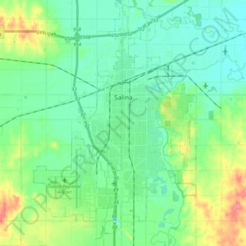
Name: Salina topographic map, elevation, terrain.
Location: Salina, Saline County, Kansas, 67401, United States (38.75464 -97.70599 38.89597 -97.55762)
Average elevation: 383 m
Minimum elevation: 362 m
Maximum elevation: 442 m
Thank you for supporting this site ❤️
Make a donation
Make a donation
Other topographic maps
Click on a map to view its topography, its elevation and its terrain.