
Make a donation
Cabauw topographic map
Click on the map to display elevation.
Make a donation
About this map
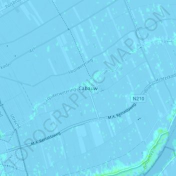
Name: Cabauw topographic map, elevation, terrain.
Location: Cabauw, Lopik, Utrecht, Netherlands, 3411 ED, Netherlands (51.94426 4.87778 51.98426 4.91778)
Average elevation: -1 m
Minimum elevation: -5 m
Maximum elevation: 5 m
Make a donation
Other topographic maps
Click on a map to view its topography, its elevation and its terrain.
Make a donation
Amersfoort
The construction of the tower and the church was started in 1444. The church was destroyed by an explosion in 1787, but the tower survived, and the layout of the church still can be discerned today through the use of different types of stone in the pavement of the open space that was created. It is now the…
Average elevation: 7 m
De Bilt
Dutch Topographic map of the municipality of De Bilt, June 2015
Average elevation: 4 m
Make a donation
Make a donation
Woudenberg
Netherlands > Utrecht > Woudenberg
Dutch Topographic map of the municipality of Woudenberg, 2013.
Average elevation: 13 m
Wijk bij Duurstede
Dutch Topographic map of the municipality of Wijk bij Duurstede, 2013.
Average elevation: 7 m
Make a donation
Make a donation
Make a donation
Amersfoort
The construction of the tower and the church was started in 1444. The church was destroyed by an explosion in 1787, but the tower survived, and the layout of the church still can be discerned today through the use of different types of stone in the pavement of the open space that was created. It is now the…
Average elevation: 7 m
Make a donation
Rhenen
Rhenen (Dutch pronunciation: [ˈreːnə(n)] ) is a municipality and a city in the central Netherlands. The municipality also includes the villages of Achterberg, Remmerden [nl], Elst and . The town lies at a geographically interesting location, namely on the southernmost part of the chain of hills known as the…
Average elevation: 13 m
Make a donation
Amersfoort
The construction of the tower and the church was started in 1444. The church was destroyed by an explosion in 1787, but the tower survived, and the layout of the church still can be discerned today through the use of different types of stone in the pavement of the open space that was created. It is now the…
Average elevation: 6 m
Make a donation
Amersfoort
The construction of the tower and the church was started in 1444. The church was destroyed by an explosion in 1787, but the tower survived, and the layout of the church still can be discerned today through the use of different types of stone in the pavement of the open space that was created. It is now the…
Average elevation: 6 m
Make a donation
Make a donation
Wijk bij Duurstede
Netherlands > Utrecht > Wijk bij Duurstede
Dutch Topographic map of the municipality of Wijk bij Duurstede, 2013.
Average elevation: 5 m
Make a donation
Make a donation
Rhenen
Netherlands > Utrecht > Rhenen
Rhenen (Dutch pronunciation: [ˈreːnə(n)] ) is a municipality and a city in the central Netherlands. The municipality also includes the villages of Achterberg, Remmerden, Elst and Laareind. The town lies at a geographically interesting location, namely on the southernmost part of the chain of hills known as…
Average elevation: 14 m
Make a donation
Montfoort
Netherlands > Utrecht > Montfoort
Dutch topographic map of the municipality of Montfoort, June 2015
Average elevation: 0 m
De Bilt
Dutch Topographic map of the municipality of De Bilt, June 2015
Average elevation: 4 m