
Thank you for supporting this site ❤️
Make a donation
Make a donation
Areekara topographic map
Click on the map to display elevation.
Thank you for supporting this site ❤️
Make a donation
Make a donation
About this map
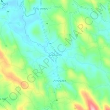
Name: Areekara topographic map, elevation, terrain.
Location: Areekara, Meenachil, Kottayam, Kerala, 686634, India (9.79262 76.59250 9.83262 76.63250)
Average elevation: 76 m
Minimum elevation: 25 m
Maximum elevation: 191 m
Thank you for supporting this site ❤️
Make a donation
Make a donation
Other topographic maps
Click on a map to view its topography, its elevation and its terrain.
Cherppungal Kulam Cheripurathu Padasekaram Karikombu
India > Kerala > Meenachil > Cherpunkal
Average elevation: 29 m
Thank you for supporting this site ❤️
Make a donation
Make a donation