
Make a donation
Kok Tobe topographic map
Click on the map to display elevation.
Make a donation
Kok Tobe
Engineers chose the Köktöbe hill due to its high altitude (1130 meters above sea level, approximately 200 meters above the city). This elevation provided optimal coverage for the tower. The design was created in collaboration with the Moscow Institute of Central Research Institute of Cryogenics, and the architects for the project were N.G. Terziev, A.N. Savchenko, and N.K. Akimov. The construction budget was set at 600 million rubles, allocated by the State Planning Committee of the USSR.
Make a donation
About this map
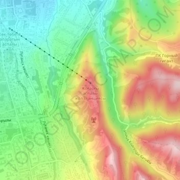
Name: Kok Tobe topographic map, elevation, terrain.
Location: Kok Tobe, Медеу ауданы, Almaty, A25D6H7, Kazakhstan (43.22310 76.96553 43.24310 76.98553)
Average elevation: 988 m
Minimum elevation: 855 m
Maximum elevation: 1,157 m
Make a donation
Other topographic maps
Click on a map to view its topography, its elevation and its terrain.
Park named after the First President of the Republic of Kazakhstan
Average elevation: 1,020 m