
Thank you for supporting this site ❤️
Make a donation
Make a donation
Pandalam topographic map
Click on the map to display elevation.
Thank you for supporting this site ❤️
Make a donation
Make a donation
About this map
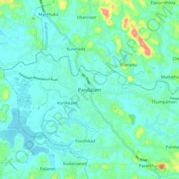
Name: Pandalam topographic map, elevation, terrain.
Location: Pandalam, Adoor, Pathanamthitta, Kerala, 689505, India (9.18512 76.63812 9.26512 76.71812)
Average elevation: 20 m
Minimum elevation: 2 m
Maximum elevation: 98 m
Thank you for supporting this site ❤️
Make a donation
Make a donation
Other topographic maps
Click on a map to view its topography, its elevation and its terrain.