
Thank you for supporting this site ❤️
Make a donation
Make a donation
Nant topographic map
Click on the map to display elevation.
Thank you for supporting this site ❤️
Make a donation
Make a donation
About this map
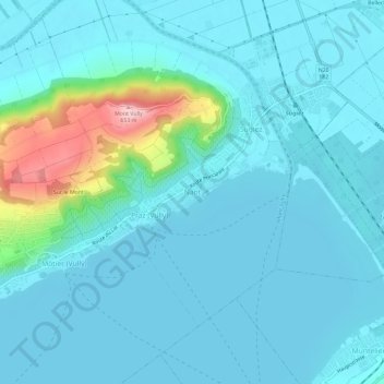
Name: Nant topographic map, elevation, terrain.
Location: Nant, Mont-Vully, District du Lac, Fribourg, 1788, Suisse (46.93515 7.08369 46.97515 7.12369)
Average elevation: 454 m
Minimum elevation: 423 m
Maximum elevation: 654 m
Thank you for supporting this site ❤️
Make a donation
Make a donation