
Thank you for supporting this site ❤️
Make a donation
Make a donation
Pechenihy topographic map
Click on the map to display elevation.
Thank you for supporting this site ❤️
Make a donation
Make a donation
About this map
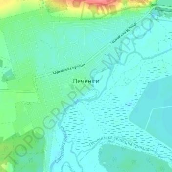
Name: Pechenihy topographic map, elevation, terrain.
Average elevation: 100 m
Minimum elevation: 87 m
Maximum elevation: 154 m
Thank you for supporting this site ❤️
Make a donation
Make a donation
Other topographic maps
Click on a map to view its topography, its elevation and its terrain.
Thank you for supporting this site ❤️
Make a donation
Make a donation
Thank you for supporting this site ❤️
Make a donation
Make a donation
Donets
The Donets originates on the Central Russian Upland, near Podolkhi village, Prokhorovka area, north of Belgorod, at an elevation of 200 m (660 ft) above sea level. Its basin contains over 3000 rivers, of which 425 are longer than 10 km (6.2 mi) and 11 are longer than 100 km (62 mi); 1011 of those rivers…
Average elevation: 128 m