
Thank you for supporting this site ❤️
Make a donation
Make a donation
Shoreview topographic map
Click on the map to display elevation.
Thank you for supporting this site ❤️
Make a donation
Make a donation
About this map
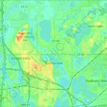
Name: Shoreview topographic map, elevation, terrain.
Location: Shoreview, Ramsey County, Minnesota, 55126, United States (45.03576 -93.18871 45.12438 -93.10621)
Average elevation: 279 m
Minimum elevation: 263 m
Maximum elevation: 329 m
Thank you for supporting this site ❤️
Make a donation
Make a donation
Other topographic maps
Click on a map to view its topography, its elevation and its terrain.
Ford Dam Scenic Overlook
United States > Minnesota > Ramsey County > Saint Paul
Average elevation: 251 m
Thank you for supporting this site ❤️
Make a donation
Make a donation