
Thank you for supporting this site ❤️
Make a donation
Make a donation
Ares topographic map
Click on the map to display elevation.
Thank you for supporting this site ❤️
Make a donation
Make a donation
About this map
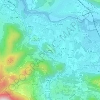
Name: Ares topographic map, elevation, terrain.
Average elevation: 534 m
Minimum elevation: 428 m
Maximum elevation: 1,007 m
Thank you for supporting this site ❤️
Make a donation
Make a donation
Other topographic maps
Click on a map to view its topography, its elevation and its terrain.
Gouffre de Lespugues
France > Occitanie > Haute-Garonne > Saint-Bertrand-de-Comminges
Average elevation: 575 m