
Thank you for supporting this site ❤️
Make a donation
Make a donation
Calvisio topographic map
Click on the map to display elevation.
Thank you for supporting this site ❤️
Make a donation
Make a donation
About this map
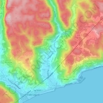
Name: Calvisio topographic map, elevation, terrain.
Location: Calvisio, Finale Ligure, Savona, Ligurien, 17024, Italien (44.16564 8.33405 44.20564 8.37405)
Average elevation: 155 m
Minimum elevation: -1 m
Maximum elevation: 348 m
Thank you for supporting this site ❤️
Make a donation
Make a donation
Other topographic maps
Click on a map to view its topography, its elevation and its terrain.
Finale Ligure
Italien > Ligurien > Savona > Finale Ligure
Finale Ligure liegt etwa 60 km südwestlich von Genua an der ligurischen Küste im Bereich der Palmenriviera. Nach Westen wird Finale Ligure durch das Capra Zoppa-Massiv (281 m) begrenzt. Nach Norden hin, nur wenige Kilometer landeinwärts, erreichen die Berge bereits Höhen von über 1000 Metern. Finale…
Average elevation: 163 m