
Make a donation
Florence Township topographic map
Click on the map to display elevation.
Make a donation
About this map
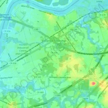
Name: Florence Township topographic map, elevation, terrain.
Average elevation: 11 m
Minimum elevation: -1 m
Maximum elevation: 32 m
Make a donation
Other topographic maps
Click on a map to view its topography, its elevation and its terrain.
Franklin Park
United States > New Jersey > Burlington County > Willingboro Township
Average elevation: 11 m
Make a donation
Indian Mills
United States > New Jersey > Burlington County > Shamong Township
Average elevation: 25 m
Make a donation
Make a donation
Colemantown
United States > New Jersey > Burlington County > Mount Laurel Township
Average elevation: 20 m
Freedom Park
United States > New Jersey > Burlington County > Medford Township
Average elevation: 16 m
Make a donation
Coxs Corner
United States > New Jersey > Burlington County > Mount Laurel Township
Average elevation: 21 m
Make a donation
Burlington
United States > New Jersey > Burlington County > Burlington City > Burlington
Average elevation: 11 m
Make a donation
Make a donation
Chambers Corners
United States > New Jersey > Burlington County > Chambers Corners
Average elevation: 19 m
Garfield Park East
United States > New Jersey > Burlington County > Willingboro > Garfield Park East
Average elevation: 16 m
Apple Pie Hill Station Fire Tower
United States > New Jersey > Burlington County > Tabernacle Township
Average elevation: 34 m
Make a donation
Fellowship
United States > New Jersey > Burlington County > Mount Laurel Township
Average elevation: 16 m