
Thank you for supporting this site ❤️
Make a donation
Make a donation
Inndyr topographic map
Click on the map to display elevation.
Thank you for supporting this site ❤️
Make a donation
Make a donation
About this map
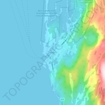
Name: Inndyr topographic map, elevation, terrain.
Location: Inndyr, Gildeskål, Нурланн, 8140, Норвегия (67.01524 14.00650 67.05524 14.04650)
Average elevation: 67 m
Minimum elevation: 0 m
Maximum elevation: 471 m
Thank you for supporting this site ❤️
Make a donation
Make a donation
Other topographic maps
Click on a map to view its topography, its elevation and its terrain.
Thank you for supporting this site ❤️
Make a donation
Make a donation