
Kanazi topographic map
Interactive map
Click on the map to display elevation.
About this map
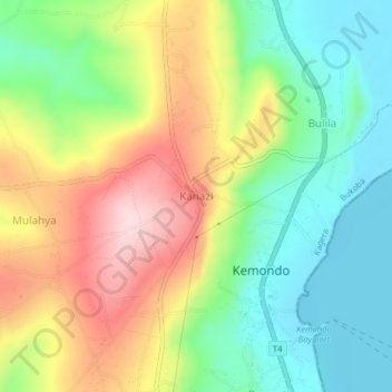
Name: Kanazi topographic map, elevation, terrain.
Location: Kanazi, Bukoba, Kagera, Lake Zone, Tanzania (-1.48486 31.71863 -1.44486 31.75863)
Average elevation: 1,244 m
Minimum elevation: 1,131 m
Maximum elevation: 1,406 m
Other topographic maps
Click on a map to view its topography, its elevation and its terrain.
Kyabishonga kibirizi
Tanzania > Kagera > Kyabishonga kibirizi
Kyabishonga kibirizi, Bukoba, Kagera, Lake Zone, Tanzania
Average elevation: 1,192 m
Nyabisindu
Tanzania > Kagera > Nyabisindu
Nyabisindu, Ngara, Kagera, Lake Zone, Tanzania
Average elevation: 1,488 m