
Thank you for supporting this site ❤️
Make a donation
Make a donation
Jintotolo Island topographic map
Click on the map to display elevation.
Thank you for supporting this site ❤️
Make a donation
Make a donation
Jintotolo Island
Its elevation was recorded at around 120 feet (37 m) in 1919. A lighthouse with a tower at 51 feet (16 m) in height exists on Jintotolo island.
Thank you for supporting this site ❤️
Make a donation
Make a donation
About this map
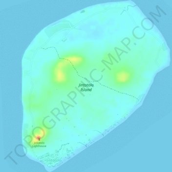
Name: Jintotolo Island topographic map, elevation, terrain.
Average elevation: 6 m
Minimum elevation: 0 m
Maximum elevation: 45 m
Thank you for supporting this site ❤️
Make a donation
Make a donation