
Thank you for supporting this site ❤️
Make a donation
Make a donation
Kirchzarten topographic map
Click on the map to display elevation.
Thank you for supporting this site ❤️
Make a donation
Make a donation
About this map
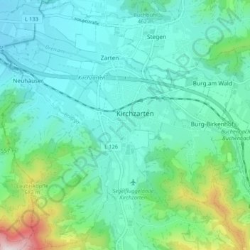
Name: Kirchzarten topographic map, elevation, terrain.
Average elevation: 458 m
Minimum elevation: 322 m
Maximum elevation: 977 m
Thank you for supporting this site ❤️
Make a donation
Make a donation
Other topographic maps
Click on a map to view its topography, its elevation and its terrain.
Thurner
Duitsland > Baden-Württemberg > Landkreis Breisgau-Hochschwarzwald > St. Märgen
Average elevation: 977 m
Hinterdorf
Duitsland > Baden-Württemberg > Landkreis Breisgau-Hochschwarzwald > Breitnau
Average elevation: 943 m