
Thank you for supporting this site ❤️
Make a donation
Make a donation
Gusum topographic map
Click on the map to display elevation.
Thank you for supporting this site ❤️
Make a donation
Make a donation
About this map
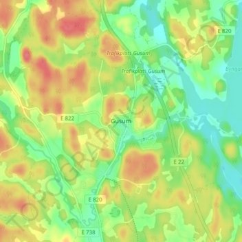
Name: Gusum topographic map, elevation, terrain.
Location: Gusum, Valdemarsviks kommun, Östergötlands län, 610 40, Zweden (58.25334 16.48160 58.29334 16.52160)
Average elevation: 54 m
Minimum elevation: 25 m
Maximum elevation: 88 m
Thank you for supporting this site ❤️
Make a donation
Make a donation
Other topographic maps
Click on a map to view its topography, its elevation and its terrain.