
Thank you for supporting this site ❤️
Make a donation
Make a donation
Mustikasari topographic map
Click on the map to display elevation.
Thank you for supporting this site ❤️
Make a donation
Make a donation
About this map
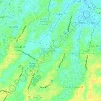
Name: Mustikasari topographic map, elevation, terrain.
Location: Mustikasari, Bekasi, West Java, Java, 17157, Indonesia (-6.31860 106.99502 -6.27860 107.03502)
Average elevation: 30 m
Minimum elevation: 19 m
Maximum elevation: 43 m
Thank you for supporting this site ❤️
Make a donation
Make a donation
Other topographic maps
Click on a map to view its topography, its elevation and its terrain.
Hutan Kota Patriot Bina Bangsa Kota Bekasi
Indonesia > West Java > Bekasi > Kayuringinjaya
Average elevation: 19 m