
Thank you for supporting this site ❤️
Make a donation
Make a donation
Engleville topographic map
Click on the map to display elevation.
Thank you for supporting this site ❤️
Make a donation
Make a donation
About this map
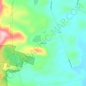
Name: Engleville topographic map, elevation, terrain.
Average elevation: 436 m
Minimum elevation: 358 m
Maximum elevation: 640 m
Thank you for supporting this site ❤️
Make a donation
Make a donation
Other topographic maps
Click on a map to view its topography, its elevation and its terrain.
Town of Summit
United States > New York > Schoharie County
Summit is a town in Schoharie County, New York, United States. The population was 1,072 at the time of the 2020 census. The name is derived from a peak (Mt. Wharton) that was thought to be the highest elevation in the county.
Average elevation: 578 m
Thank you for supporting this site ❤️
Make a donation
Make a donation
Thank you for supporting this site ❤️
Make a donation
Make a donation
Thank you for supporting this site ❤️
Make a donation
Make a donation
Village of Cobleskill
United States > New York > Schoharie County > Town of Cobleskill
Average elevation: 345 m
Thank you for supporting this site ❤️
Make a donation
Make a donation