
Thank you for supporting this site ❤️
Make a donation
Make a donation
Hahn topographic map
Click on the map to display elevation.
Thank you for supporting this site ❤️
Make a donation
Make a donation
About this map
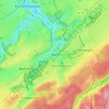
Name: Hahn topographic map, elevation, terrain.
Average elevation: 286 m
Minimum elevation: 225 m
Maximum elevation: 364 m
Thank you for supporting this site ❤️
Make a donation
Make a donation
Other topographic maps
Click on a map to view its topography, its elevation and its terrain.
Eilendorf
Deutschland > Nordrhein-Westfalen > Städteregion Aachen > Aachen
Die Kirche St. Apollonia steht im Oberdorf an der Heckstraße auf Höhe des Apolloniawegs. Das vom Aachener Architekt Peter Salm entworfene Gebäude wurde in den Jahren 1959 bis 1961 errichtet, nachdem die zuvor als Kirchengebäude dienende Apolloniakapelle aus dem 18. Jahrhundert sich als zu klein und…
Average elevation: 203 m