
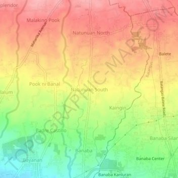
Natunuan South topographic map
Interactive map
Click on the map to display elevation.
About this map
Name: Natunuan South topographic map, elevation, terrain.
Average elevation: 132 m
Minimum elevation: 64 m
Maximum elevation: 182 m
Other topographic maps
Click on a map to view its topography, its elevation and its terrain.
Santo Niño
Philippines > Batangas > San Pascual
Santo Niño, San Pascual, Batangas, Calabarzon, 4204, Philippines
Average elevation: 46 m
Pook ni Banal
Philippines > Batangas > San Pascual > Pook ni Banal
Pook ni Banal, San Pascual, Batangas, Calabarzon, 4204, Philippines
Average elevation: 131 m
San Pascual
Philippines > Batangas > San Pascual
San Pascual, Batangas, Calabarzon, 4204, Philippines
Average elevation: 41 m