
Make a donation
Volland topographic map
Click on the map to display elevation.
Make a donation
About this map
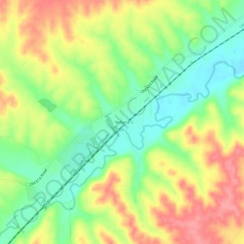
Name: Volland topographic map, elevation, terrain.
Location: Volland, Wabaunsee County, Kansas, United States (38.92445 -96.42444 38.96445 -96.38444)
Average elevation: 387 m
Minimum elevation: 346 m
Maximum elevation: 433 m
Make a donation
Other topographic maps
Click on a map to view its topography, its elevation and its terrain.
Alta Vista
United States > Kansas > Wabaunsee County
Alta Vista was founded in 1887, and it was incorporated as a city in 1905. Alta Vista is derived from the Spanish word for "high view", and the city was so named from its lofty elevation.
Average elevation: 443 m
Mount Mitchell Heritage Prairie Park
United States > Kansas > Wabaunsee County > Wamego
Average elevation: 325 m
Make a donation
Maple Hill
United States > Kansas > Wabaunsee County
Maple Hill was founded about 1882. It was named from a grove of maple trees growing upon an elevation.
Average elevation: 298 m