
Thank you for supporting this site ❤️
Make a donation
Make a donation
Sulphur Springs topographic map
Click on the map to display elevation.
Thank you for supporting this site ❤️
Make a donation
Make a donation
About this map
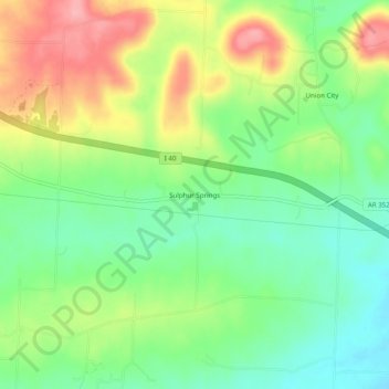
Name: Sulphur Springs topographic map, elevation, terrain.
Location: Sulphur Springs, Johnson County, Arkansas, United States (35.45758 -93.58408 35.49758 -93.54408)
Average elevation: 163 m
Minimum elevation: 116 m
Maximum elevation: 230 m
Thank you for supporting this site ❤️
Make a donation
Make a donation
Other topographic maps
Click on a map to view its topography, its elevation and its terrain.