
Ocoee River topographic map
Interactive map
Click on the map to display elevation.
About this map
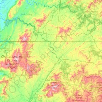
Name: Ocoee River topographic map, elevation, terrain.
Location: Ocoee River, Fannin County, Georgia, 03513, USA (34.66655 -84.69375 35.20643 -84.06710)
Average elevation: 579 m
Minimum elevation: 214 m
Maximum elevation: 1,269 m
Other topographic maps
Click on a map to view its topography, its elevation and its terrain.
Ferrell Crossroads
USA > Georgia > Ferrell Crossroads
Ferrell Crossroads, Early County, Georgia, USA
Average elevation: 94 m
Cameron Point
USA > Georgia > Cameron Point
Cameron Point, Hall County, Georgia, 30506:30534, USA
Average elevation: 339 m