
Thank you for supporting this site ❤️
Make a donation
Make a donation
Ferrières topographic map
Click on the map to display elevation.
Thank you for supporting this site ❤️
Make a donation
Make a donation
About this map
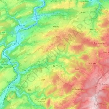
Name: Ferrières topographic map, elevation, terrain.
Location: Ferrières, Huy, Liège, Wallonia, 4190, Belgium (50.36534 5.51865 50.46017 5.70934)
Average elevation: 265 m
Minimum elevation: 101 m
Maximum elevation: 483 m
Thank you for supporting this site ❤️
Make a donation
Make a donation
Other topographic maps
Click on a map to view its topography, its elevation and its terrain.
Thank you for supporting this site ❤️
Make a donation
Make a donation
Thank you for supporting this site ❤️
Make a donation
Make a donation
Thank you for supporting this site ❤️
Make a donation
Make a donation