
Falkenfels topographic map
Interactive map
Click on the map to display elevation.
About this map
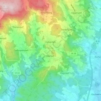
Name: Falkenfels topographic map, elevation, terrain.
Average elevation: 449 m
Minimum elevation: 329 m
Maximum elevation: 742 m
Other topographic maps
Click on a map to view its topography, its elevation and its terrain.
Sankt Englmar
Deutschland > Bayern > Landkreis Straubing-Bogen
Sankt Englmar, Landkreis Straubing-Bogen, Bayern, 94379, Deutschland
Average elevation: 712 m
Schwarzach
Deutschland > Bayern > Landkreis Straubing-Bogen
Schwarzach, Schwarzach (VGem), Landkreis Straubing-Bogen, Bayern, 94374, Deutschland
Average elevation: 471 m