
Thank you for supporting this site ❤️
Make a donation
Make a donation
Granges-Paccot topographic map
Click on the map to display elevation.
Thank you for supporting this site ❤️
Make a donation
Make a donation
About this map
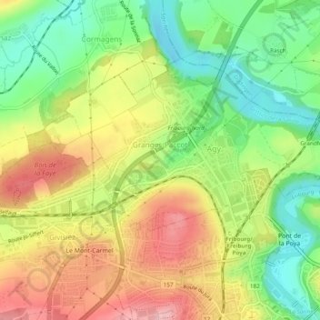
Name: Granges-Paccot topographic map, elevation, terrain.
Location: Granges-Paccot, District de la Sarine, Fribourg, 1763, Suisse (46.81186 7.12420 46.83289 7.17201)
Average elevation: 605 m
Minimum elevation: 524 m
Maximum elevation: 697 m
Thank you for supporting this site ❤️
Make a donation
Make a donation
Other topographic maps
Click on a map to view its topography, its elevation and its terrain.