
Thank you for supporting this site ❤️
Make a donation
Make a donation
Ravna Gora topographic map
Click on the map to display elevation.
Thank you for supporting this site ❤️
Make a donation
Make a donation
About this map
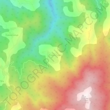
Name: Ravna Gora topographic map, elevation, terrain.
Average elevation: 877 m
Minimum elevation: 455 m
Maximum elevation: 1,335 m
Thank you for supporting this site ❤️
Make a donation
Make a donation
Other topographic maps
Click on a map to view its topography, its elevation and its terrain.
Јастребац
Serbia > Central Serbia > Jablanica Administrative District > Vlasotince Municipality > Donja Lopusnja
Average elevation: 815 m
Stajkovce
Serbia > Central Serbia > Jablanica Administrative District > Vlasotince Municipality
Average elevation: 285 m