
Thank you for supporting this site ❤️
Make a donation
Make a donation
Baie-du-Febvre topographic map
Click on the map to display elevation.
Thank you for supporting this site ❤️
Make a donation
Make a donation
About this map
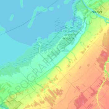
Name: Baie-du-Febvre topographic map, elevation, terrain.
Average elevation: 18 m
Minimum elevation: 1 m
Maximum elevation: 59 m
Thank you for supporting this site ❤️
Make a donation
Make a donation
Other topographic maps
Click on a map to view its topography, its elevation and its terrain.
Pointe aux Sables
Canada > Québec > Nicolet-Yamaska > Nicolet > Port-Saint-François
Average elevation: 5 m