
Make a donation
Cascades topographic map
Click on the map to display elevation.
Make a donation
About this map
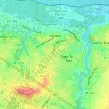
Name: Cascades topographic map, elevation, terrain.
Location: Cascades, Loudoun County, Virginia, 20165, United States (39.02155 -77.40758 39.06476 -77.36175)
Average elevation: 78 m
Minimum elevation: 55 m
Maximum elevation: 131 m
Make a donation
Other topographic maps
Click on a map to view its topography, its elevation and its terrain.
Blue Ridge
United States > Virginia > Loudoun County
Blue Ridge Mountain is noticeably lower in elevation than other sections of the Blue Ridge Mountains in Virginia. The southern section of the mountain contains the highest peaks, and the ridge gradually loses elevation as it gets closer to the Potomac. Elevations in the gaps are typically around 1,000 feet…
Average elevation: 183 m
Middleburg
United States > Virginia > Loudoun County
According to the United States Census Bureau, the town has a total area of 0.6 square mile (1.5 km2), all land. The elevation is 486 feet.
Average elevation: 144 m
Make a donation
Make a donation
Washington & Old Dominion Trail Regional Park
United States > Virginia > Loudoun County > Purcellville
Average elevation: 162 m
Make a donation
Make a donation