
Thank you for supporting this site ❤️
Make a donation
Make a donation
Birdsview topographic map
Click on the map to display elevation.
Thank you for supporting this site ❤️
Make a donation
Make a donation
About this map
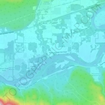
Name: Birdsview topographic map, elevation, terrain.
Location: Birdsview, Skagit County, Washington, United States (48.50233 -121.89542 48.54233 -121.85542)
Average elevation: 73 m
Minimum elevation: 29 m
Maximum elevation: 354 m
Thank you for supporting this site ❤️
Make a donation
Make a donation
Other topographic maps
Click on a map to view its topography, its elevation and its terrain.
Thank you for supporting this site ❤️
Make a donation
Make a donation
Thank you for supporting this site ❤️
Make a donation
Make a donation
Thank you for supporting this site ❤️
Make a donation
Make a donation
Skyline Home Owners Association
United States > Washington > Skagit County > Anacortes
Average elevation: 14 m
Thank you for supporting this site ❤️
Make a donation
Make a donation
Thank you for supporting this site ❤️
Make a donation
Make a donation
Concrete
United States > Washington > Skagit County
Mears Field (3W5), formerly known as Concrete Municipal Airport, is located one mile south of Concrete at an elevation of 267 ft MSL.
Average elevation: 125 m