
Thank you for supporting this site ❤️
Make a donation
Make a donation
Abilakin topographic map
Click on the map to display elevation.
Thank you for supporting this site ❤️
Make a donation
Make a donation
About this map
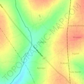
Name: Abilakin topographic map, elevation, terrain.
Location: Abilakin, Bukedea, Eastern Region, Uganda (1.34986 34.00815 1.38986 34.04815)
Average elevation: 1,113 m
Minimum elevation: 1,083 m
Maximum elevation: 1,135 m
Thank you for supporting this site ❤️
Make a donation
Make a donation