
Make a donation
Mount Meharry topographic map
Click on the map to display elevation.
Make a donation
Mount Meharry
The summit of Mount Meharry can be reached from the Great Northern Highway via an unsealed road 16 kilometres (9.9 mi) in length and a vehicular track 21 kilometres (13 mi) in length. Permission should be sought from the managers of the land over which the road and track pass. These are Juna Downs Station and the Department of Parks and Wildlife, which manages Karijini National Park. In dry conditions, a two-wheel-drive vehicle can reach the national park boundary at about 800 metres (2,600 ft) elevation, requiring a walk of about 7 kilometres (4.3 mi) to the summit.
Make a donation
About this map
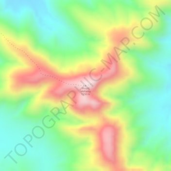
Name: Mount Meharry topographic map, elevation, terrain.
Average elevation: 1,030 m
Minimum elevation: 859 m
Maximum elevation: 1,247 m
Make a donation
Other topographic maps
Click on a map to view its topography, its elevation and its terrain.
Make a donation
Make a donation
Make a donation
Make a donation
The Vines
Topographically, The Vines sits on a gradual incline that descends towards the Ellen Brook valley. The west of the suburb sits at 30 metres above sea level, dropping to 20 metres in the east around the brook and the Sawpit Gully.
Average elevation: 27 m
Make a donation
Make a donation
Make a donation
Make a donation
Make a donation
Make a donation
Aveley
Topographically, most of Aveley sits on even ground between 25-30 metres above sea level. The Ellen Brook cuts through a steep valley to the east. The western edge of the suburb is situated on a large hill on the Gnangara Mound, reaching 50 metres above sea level.
Average elevation: 36 m
Make a donation
Make a donation
Make a donation
Make a donation
Make a donation
Make a donation
Make a donation
Make a donation
Make a donation
Make a donation
Make a donation
Make a donation
Make a donation
Make a donation
Make a donation