
Baños topographic map
Interactive map
Click on the map to display elevation.
About this map
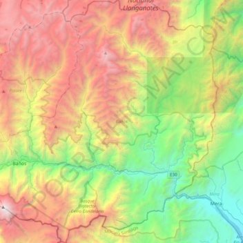
Name: Baños topographic map, elevation, terrain.
Location: Baños, Tungurahua, Ecuador (-1.52314 -78.47907 -1.14052 -78.11020)
Average elevation: 2,641 m
Minimum elevation: 980 m
Maximum elevation: 4,992 m
Other topographic maps
Click on a map to view its topography, its elevation and its terrain.
Aire Libre
Ecuador > Tungurahua > Cevallos
Aire Libre, Cevallos, Tungurahua, 180403, Ecuador
Average elevation: 2,871 m
Ambato
Ecuador > Tungurahua > Ambato > Ambato
Ambato, Tungurahua, 0838, Ecuador
Average elevation: 3,145 m
El Galpon
Ecuador > Tungurahua > El Galpon
El Galpon, Ambato, Tungurahua, Ecuador
Average elevation: 3,281 m
Montañitas
Ecuador > Tungurahua > Patate > El Triunfo
Montañitas, El Triunfo, Patate, Tungurahua, Ecuador
Average elevation: 2,576 m