
Weißenburg i. Bay. topographic map
Interactive map
Click on the map to display elevation.
About this map
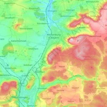
Name: Weißenburg i. Bay. topographic map, elevation, terrain.
Average elevation: 490 m
Minimum elevation: 386 m
Maximum elevation: 637 m
Other topographic maps
Click on a map to view its topography, its elevation and its terrain.
Furthmühle
Duitsland > Beieren > Landkreis Weißenburg-Gunzenhausen > Rehenbühl
Furthmühle, Rehenbühl, Pfofeld, Gunzenhausen (VGem), Landkreis Weißenburg-Gunzenhausen, Beieren, 91738, Duitsland
Average elevation: 437 m