
Make a donation
Neapoli Municipal Unit topographic map
Click on the map to display elevation.
Make a donation
About this map
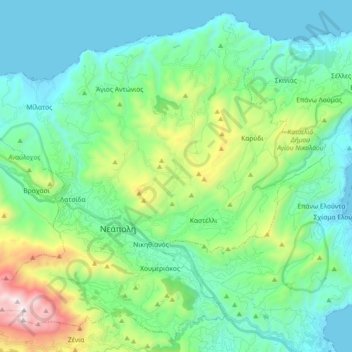
Name: Neapoli Municipal Unit topographic map, elevation, terrain.
Average elevation: 332 m
Minimum elevation: -1 m
Maximum elevation: 1,477 m
Make a donation
Other topographic maps
Click on a map to view its topography, its elevation and its terrain.
Agia Fotia
Greece > Region of Crete > Lasithi Regional Unit > Sitia Municipal Unit
Average elevation: 140 m
Krioneri
Greece > Region of Crete > Lasithi Regional Unit > Itanos Municipal Unit
Average elevation: 574 m
Palaikastro
Greece > Region of Crete > Lasithi Regional Unit > Itanos Municipal Unit
Average elevation: 76 m
Agios Andreas
Greece > Region of Crete > Lasithi Regional Unit > Sitia Municipal Unit
Average elevation: 92 m
Make a donation
Kritsa
Greece > Region of Crete > Lasithi Regional Unit > Agios Nikolaos Municipal Unit
Kritsa (Greek: Κριτσά, romanized: Critsá) is one of the oldest and most picturesque villages in Crete, Greece, built amphitheatrically on a rock hill, named Kastellos, surrounded by olive groves, at an altitude of 375 m. It is part of the municipality of Agios Nikolaos. During the Middle Ages, it was…
Average elevation: 446 m
Anemomilia
Greece > Region of Crete > Lasithi Regional Unit > Sitia Municipal Unit
Average elevation: 54 m