
Thank you for supporting this site ❤️
Make a donation
Make a donation
Lakeside Village topographic map
Click on the map to display elevation.
Thank you for supporting this site ❤️
Make a donation
Make a donation
About this map
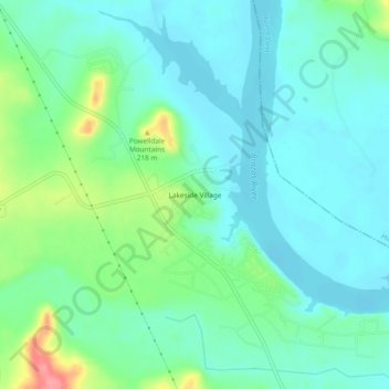
Name: Lakeside Village topographic map, elevation, terrain.
Location: Lakeside Village, Bosque County, Texas, 76617, United States (32.00099 -97.51391 32.04099 -97.47391)
Average elevation: 177 m
Minimum elevation: 156 m
Maximum elevation: 242 m
Thank you for supporting this site ❤️
Make a donation
Make a donation
Other topographic maps
Click on a map to view its topography, its elevation and its terrain.