
Thank you for supporting this site ❤️
Make a donation
Make a donation
Condamine River topographic map
Click on the map to display elevation.
Thank you for supporting this site ❤️
Make a donation
Make a donation
About this map
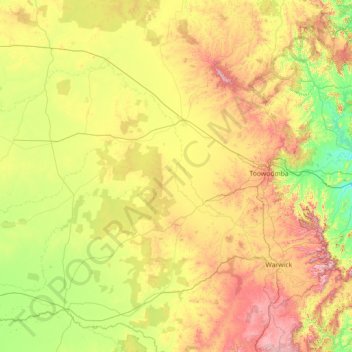
Name: Condamine River topographic map, elevation, terrain.
Location: Condamine River, Australia (-28.38123 149.62590 -26.77782 152.47932)
Average elevation: 376 m
Minimum elevation: 36 m
Maximum elevation: 1,302 m
Thank you for supporting this site ❤️
Make a donation
Make a donation
Other topographic maps
Click on a map to view its topography, its elevation and its terrain.
Thank you for supporting this site ❤️
Make a donation
Make a donation
Thank you for supporting this site ❤️
Make a donation
Make a donation
Thank you for supporting this site ❤️
Make a donation
Make a donation
Thank you for supporting this site ❤️
Make a donation
Make a donation