
Thank you for supporting this site ❤️
Make a donation
Make a donation
Kanchan topographic map
Click on the map to display elevation.
Thank you for supporting this site ❤️
Make a donation
Make a donation
About this map
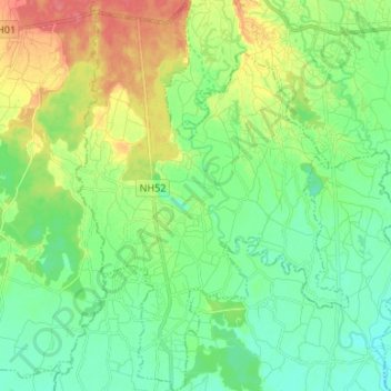
Name: Kanchan topographic map, elevation, terrain.
Location: Kanchan, Rupandehi, Lumbini Province, Nepal (27.57975 83.22049 27.69738 83.31335)
Average elevation: 124 m
Minimum elevation: 102 m
Maximum elevation: 166 m
Thank you for supporting this site ❤️
Make a donation
Make a donation
Other topographic maps
Click on a map to view its topography, its elevation and its terrain.